
OCEANOGRAPHY |
Climate Change: What is happening in the ocean? |
| ©
Joachim Ribbe, 2001 Joachim.Ribbe@usq.edu.au |
[RESUMEN] ABSTRACT
There is continued scientific and public debate about the possibility of future climatic changes that may result from human activity such as the burning of fossil fuels since the 18th century. Within this context, the article provides a brief review of the ocean's role within the global climate system. It illustrates how the ocean regulates the Earth's climate and how it asserts control over the climate system. One key feature of the present state of the ocean climate is a global thermohaline circulation, which allows for an exchange of heat and greenhouse gases in a conveyor belt type fashion throughout the ocean interior. Continuous mixing of surface water into the deep ocean caused by complex ocean and atmosphere processes may have already led to a global ocean warming. The detection of a human induced greenhouse effect against the background of natural climate variability is a difficult task. Daily, seasonal, or decadal changes in temperature, for example, are much larger than the anticipated human induced temperature increase of only several tenths of a degree. This climate variability is discussed by using several prominent examples. In the last section of this article, observations of climate variability in the South Pacific Ocean are described. It is here, where a fingerprint of global ocean warming may have already been found in recently collected data. When compared to historical data records from the 1960s, these new data indicate a warming of the subsurface ocean. Today's policy and decision makers wait for more pronounced signals of an enhanced greenhouse effect to arrive and scientists continue to search for further convincing evidence. However, one benefit of global climate and ocean research is the discovery and study of a suite of previously unknown climate system phenomena during the last two decades.
Part I: The Mean State of the Climate System
The natural greenhouse effect makes life on Earth possible. Without the protecting atmospheric shield and its natural content of water vapour, carbon dioxide, and other greenhouse gases, the mean temperature at the Earth surface would be about -19oC. Most life in its present form would be impossible. Instead, incoming short wave solar radiation is reflected at the Earth's surface as long wave radiation and atmospheric greenhouse gases prevent its escape into space. These gases absorb the long wave radiation emitted from the Earth surface and heat the planet to the globally averaged surface temperature of about +15 oC . The natural balance between incoming short wave solar and outgoing long wave terrestrial radiation maintains the equilibrium state of the global climate system (e.g. Intergovernmental Panel on Climate Change, 1995; see also web link). A logical consequence of changes in atmospheric greenhouse gas concentrations would be, for example, changes to the mean temperature. There is now convincing evidence from observations and modelling studies of the global climate system that this is indeed happening. Thus, the steady state climate system is being interfered with by human activity.
The amount of incoming solar radiation is unevenly distributed over the Earth surface. Continuous exchanges of heat between the ocean and atmosphere take place and oceanic heat gains are large at the equator, while heat is lost to the atmosphere in polar regions. This disparity results in a transport of heat between equatorial and polar regions, with both the atmosphere and ocean transporting about the same amount of heat away from the equator. The temperature gradient maintained by incoming solar radiation is a primary force in driving the global atmospheric and oceanic circulation. While ocean and atmosphere play a similar role in the poleward transport of heat, the storage of heat within the interior of both is quite different. The entire amount atmospheric heat is contained within the top 1-2 meter of the global ocean. This is due to the large heat capacity of water and its ability to absorb heat. As a result, the ocean, which covers about 70 per cent of the Earth surface, becomes that part of the global climate system, which controls the climatological mean state of the coupled ocean, atmosphere, and land system. It buffers atmospheric temperature fluctuations by releasing or storing heat. A well studied example, how the global ocean circulation asserts control over the mean state of the climate system and moderates atmospheric conditions is that of the North Atlantic Ocean circulation. The Gulf Stream and its extension toward Europe moves heat into the higher latitudes. There it is lost to the atmosphere and moderates the regional climate of Northwest Europe.
The North Atlantic Ocean surface layer circulation is part of a global ocean circulation which is primarily wind driven, but it also forms the upper branch of a global ocean thermohaline circulation. This circulation operates on time scales of several centuries. It moves water from one region to another much slower than any wind driven ocean currents. The flow is driven by a combination of surface water cooling, freshening, freezing, the formation of dense water in the polar regions of both hemispheres, vertical mixing, and upward motion in other parts of the ocean. To compensate for the formation of cold, and dense, sinking water, warmer and lighter surface water is transported into regions of water loss, which closes a global circulation loop. This ocean conveyor is a key feature of the global climate system and controls its mean state (Figure 1).
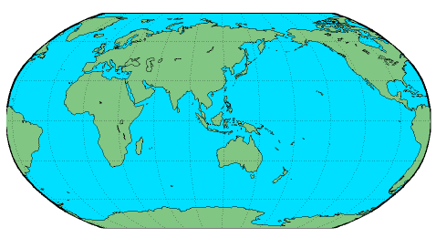
Figure 1: Animation of the global conveyor belt circulation based upon Broecker (1991) and others since. This schematic is only a very rough approximation of the real situation found in the ocean which is by far more complex than it can be indicated here. The global ocean conveyor belt circulation is primarily driven by the formation of cold and dense water in both the northern and southern hemispheres; here indicated in blue. Both deep water flows join each other in the Southern Hemisphere to form part of the eastward flowing Antarctic Circumpolar Current. From there it branches off into the deep Indian and Pacific Ocean where water up-wells to the surface and forms a warm salty return flow into the Northern Hemisphere (in red). See text for some more details.
Atmospheric greenhouse gases such as carbon dioxide determine the mean temperature of the atmosphere. Similar to heat fluxes between the atmosphere and ocean, these gases are continuously exchanged with the ocean. The biosphere, atmosphere, and ocean are the three carbon reservoirs which are relevant to the anthropogenic perturbation of the global carbon cycle. Of these, the ocean is the largest and most of the carbon dioxide released by burning fossil fuels such as coal and gas will eventually be stored in the deep ocean. The natural storing process itself is driven by a combination of deep and bottom water production in polar regions, and biological processes operating throughout the global ocean. Both processes pump carbon into the ocean and are referred as the solubility and biological pump. The sinking of surface water is often thought of as a ventilation mechanism, because oxygen saturated surface water flows into the deeper parts of the world ocean where it rejuvenates oxygen depleted subsurface water. The sinking regions of the global ocean are the windows through which the deep ocean communicates with the atmosphere. Away from these windows, properties such as oxygen or carbon dioxide are carried throughout the interior of the ocean in a conveyor belt type fashion. A parcel of sinking surface water and with it, its content of atmospheric properties, will take on average several centuries to return eventually to the surface and its starting position. As such, the ocean acts as a geological short-term memory of past climatic states of the atmosphere. In essence, it can be referred to as the flywheel of the climate system because the oceanic storage of atmospheric properties upon time scales of several centuries alters atmospheric conditions of future climates.
Most of the water mass sinking that drive the global thermohaline or density driven circulation was originally thought to occur in the North Atlantic Ocean. Here about an average of 10 to 15 million cubic meter of water per second, about 10 times the equivalent of all the freshwater water entering the ocean via rivers, is plunging down to water depths of several thousands of meters (Figure 1). This water is referred to as North Atlantic Deep Water. To replace the total ocean contents of water due to this deep water formation process about 1000 years are required, which establishes a time scale for the global conveyor belt circulation. The water filling up the deep ocean at present, has been in contact last with the atmosphere several centuries ago.
From the northern polar regions, deep water is flowing as a deep ocean current southward, it crosses the Equator and moves into the Southern Hemisphere where it finally joins the primarily wind driven eastward flow of the Antarctic Circumpolar Current. This current is the longest current of the world ocean spanning the globe with a total length of about 16000 kilometres and no continental boundaries limit its eastward flow. Its flow facilitates the transport of North Atlantic Deep Water into the deeper layers of the Indian and Pacific Ocean. Due to conservation principles, meaning that North Atlantic Deep Water removed in the Northern Hemisphere must be replaced by a flow of surface water northward, it is here in the Southern Hemisphere, and the Indian and Pacific Ocean, where water up-wells and deep ocean properties slowly move upward into the ocean surface. This upward motion is very slow, a global ocean basin average is about 4-5 m per year. Surface water forms a less dense branch of the thermohaline circulation that moves as a surface current joining the wind driven upper ocean circulation back into the North Atlantic Ocean.
This simple concept of the global ocean thermohaline circulation emerged during the last fifty years starting with fundamental work by Stommel and Arons (1960a, 1960b) and Munk (1966), and culminated in Broecker's (1991) widely published schematic of the global conveyor. Recently, researchers returned to a hypothesis originally proposed by Stommel and Arons (1960a, 1960b). It is argued again that an equivalent amount of bottom water is formed in the Southern Ocean (Broecker et al, 1998) which contributes a second equally sized source driving the global conveyor belt circulation. Also under evaluation is the early view that the upward motion of deep and bottom water takes place uniformly throughout the ocean (Munk and Wunsch, 1998). There is indication that the upward motion of cold and heavy deep ocean water is made possible through the action of global tides resulting from the motion of Moon and Sun around Earth. Much of the tidal energy is dissipated above rough ocean floor topography near mid-ocean ridges, continental slopes, and shelf seas enhancing locally vertical mixing that traditionally was thought to be uniform throughout the interior of the ocean. This mixing stirs cold bottom and warm surface water; it warms the deep ocean and cools the surface water.
The present global thermohaline circulation depends upon a balance of surface freshwater and heat fluxes into the North Atlantic Ocean. Both properties control ocean surface water density and buoyancy. There is evidence now that this balance was perturbed in the past. The global thermohaline circulation collapsed on various occasions throughout the geological history. The actual collapse may occur over a period of only several decades, a rapid process considering other geological processes, with major consequence for regional to global atmospheric conditions. The Gulf Stream forming part of the return flow within this global conveyor type belt circulation transports much heat toward the northeast Atlantic which moderates the European climate. A collapse of this system and a shut-down of this European heat source would have obvious regional consequence.
At present, continued research into the global thermohaline circulation is taking place through global ocean and climate modelling studies. An ever increasing amount of observations describing the geological history of the Earth and its climate system serves to validate and confirm output from models, which are the only tools allowing to forecast the consequences of future climate changes. The World Ocean Circulation Experiment which is coordinated through an international project office in the United Kingdom (WOCE; see web link below) commenced in the early 90s to establish a global database recording the present state of the ocean climate. The data base will be available to monitor future global climate changes (Siedler et al. 2001).
Part II: Ocean Climate Variability
The climate of the Earth, which can be described through variables such as a mean global surface temperature, undergoes variations on many time scales. Some result in quasi permanent changes to the mean surface temperature, hence result in climatic change. An example is the switch from glacial to interglacial periods and vice verse that occurs over geological time scales of several tenths of thousands of years. Many initiatives are underway to record the present state of the interglacial climate period. The World Ocean Circulation Experiment mentioned previously will, for example, provide us with an up-to-date view of the ocean's present interglacial climate state. Changes to the mean state of the present climate which occur on time scales such as months, years, decades or even centuries are understood as natural variability. The annual march through the seasons, for example, results in an alternating warming and cooling of the upper ocean on the order of several degrees (Figure 2). Having established a base line for our present climate state through experiments such as the World Ocean Circulation Experiment, the Climate Variability and Predictability program (CLIVAR; see web link below) with international participation commenced only recently to study all aspects of Earth's variable climate system during the next decade.
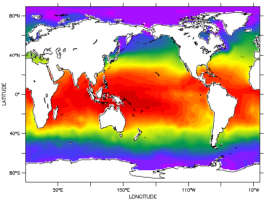
Figure 2: This is an animation of the seasonal sea surface temperature cycle based upon the Levitus (1994) climatology. Shading is done in intervals of 1oC. Notice the alternating cooling and warming in each hemisphere indicated by a north to south and vice verse movement of the temperature isolines. Highest sea surface temperatures (larger than 30o S shaded in red) are found in the equatorial regions; with the warm water pool in the western equatorial Pacific Ocean north of Australia. Also notice the cold water tongue in the eastern equatorial Pacific Ocean and the cooling of the eastern South Pacific Ocean during the Southern Hemisphere winter. In both hemispheres, the coldest surface water is found in the polar regions shaded in blue.
An ever increasing amount of observational evidence, theoretical, and modelling studies is becoming available, which indicates that the climatolgical mean state, or the equilibrium state of the global climate system, is actively being perturbed by society. Since the begin of the 18th century, modern society started to heavily rely upon the use of fossil fuels such as coal, oil, and gas. These contain vast quantities of carbon, which during combustion is released into the atmosphere as carbon dioxide. In fact, since continuous atmospheric carbon dioxide concentrations commenced in the early 50s and a global network of measurement stations was subsequently established, the observed rapid increase is without any historical precedence. Nowadays, the concentration of atmospheric carbon dioxide increases is much faster than during any other time of the geological record. The historical record of atmospheric temperature and carbon dioxide concentrations exhibits a strong correlation between these two atmospheric properties. The record extents several tens of thousand of years into the geological past, and it appears that increases in carbon dioxide concentrations are followed by temperature increases.
Initially, only theoretical and modelling studies of the global climate system suggested that the vast amount of carbon released by society into the atmosphere may alter the mean temperature of the present climate state. During the last decade, huge efforts were made to detect this increase in the mean Earth surface temperature through observations. The search and detection of a fingerprint of human induced climate change is desired by many people working within policy making institutions. Such a finding would provide clear guidance for policy makers and future greenhouse gas abating measures. In its most recent draft report, the Intergovernmental Panel on Climate Change (IPCC; see web link below) representing a scientific consensus by more than 2000 climate researchers, confirmed its 1995 finding: Human activity is changing the global climate system shifting it to a warmer global mean state.
The effort to detect human induced climatic changes from observations is made particularly difficult as the climate system exhibits variability on many time scales. The temperature range associated with such variability exceeds the anticipated global temperature increase due to an enhanced greenhouse effect by several degrees (see Figure 2). Variability of the climate system ranges from daily and the seasonal cycle of sea surface temperature to interannual phenomena such as the El Nino Southern Oscillation and those changes such as the North Atlantic Oscillation which occur over several decades. Daily temperature changes propagate only several tens of meters below the ocean surface, where as seasonal changes reach to a few hundred meters and producing seasonally varying mixed layer depths (Figure 3). The ocean buffers any short termed variability, however, longer lasting atmospheric perturbations impact upon the larger global scale ocean circulation which in turn, feed back to effect the atmospheric circulation.
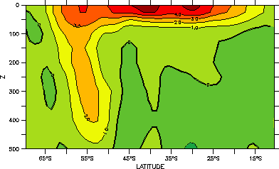
Figure 3 : Mean temperature anomaly within the top 500 m in the South Pacific Ocean (see Figure 2). The anomaly is computed as the difference between the January and September temperature. During the Southern Hemisphere winter, the surface layer between 20-40o S is about 1 - 5oC warmer ( shaded in red). Between about 50-60o S, a temperature anomaly reaches down to depths of about 400- 500 m. This is an area where surface water cooling and deep mixing results in the formation of water masses (see text below). Below this mixed layer, the ocean is not affected by any seasonal atmospheric temperature changes. The data is from the Levitus (1994) climatology.
A well known and researched example of inter-annual variability is the El Nino Southern Oscillation in the equatorial Pacific Ocean (ENSO; see web link below). Under normal conditions, the equatorial trade winds push warm surface water from the east to the west establishing a warm water pool in the western equatorial Pacific with the highest sea surface temperature of the global ocean (see Figure 2, dark red shading). During El Nino events, a relaxation or even reversal of the trade winds pushes this warm surface water from the west to the east resulting in an abnormal warming of the eastern Pacific Ocean upon intervals of about 3 - 4 years. A return to normal wind conditions results in a reversal of this flow moving the warm water pool back toward the western Pacific Ocean. This oscillation is comparable to a seesaw effect causing interannual variation of sea surface temperature (Figure 4). An overshoot of the warm water flow farther to the west than under normal conditions results in a La Nina event, an unusual cooling in the eastern Pacific Ocean. In consequence, the alternating ocean and atmosphere circulation is associated with, for example rainfall anomalies and resulting consequences for societies and economies. Whole fishing industries are known to collapse as oceanic conditions change. The 1982 El Niño episode has been estimated to cost the global economy more than 8 billion dollars, not to mention human losses due to flooding, land slides, and other natural disasters.
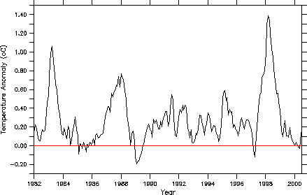
Figure 4: This is a representation of the monthly mean sea surface temperature anomaly computed for the Niño 1+2 area (0o-10oS and 90o-80o W) which is located in the eastern Pacific Ocean (data source: Smith et al. 1996). There are three main peaks in about 1983, 1987 and 1998. During those years, El Niño events occurred which resulted in anomalies to sea surface temperature, i.e. an unusual warming of the eastern Pacific Ocean. In other years such as in about 1989 and 1997 lower sea surface temperatures are indicative of a La Niña phase, that is an unusual cooling of the eastern Pacific Ocean.
Much effort has gone into understanding the physical forces that drive this particular interannual variability of the coupled equatorial ocean and atmosphere system. It has lead to the establishment of an ocean monitoring system which consists of an array of about seventy permanent moorings along the equatorial Pacific Ocean (the TAO array; see web link below) . These continuously monitor oceanic and atmospheric conditions such as temperature and wind speed. An ocean observing system in combination with the development of coupled ocean and atmosphere models, now allows to predict future events with a certain degree of confidence. From recent analysis of satellite based ocean surface temperature and ocean current meter measurements, it was also concluded that the onset of an equatorial El Nino event may be preceded by several months of warming in the eastern South Pacific Ocean. Monitoring temperature changes in those locations could establish something like an early forecasting system for a looming equatorial El Nino event (Shaffer et al. 1999).
Research into climate variability and global monitoring of the ocean and atmosphere system has lead to the discovery of other perturbations to the global climate system. The more recent ones have become known as the Antarctic Circumpolar Wave, the North Atlantic Oscillation, and the Indian Ocean Dipole. These perturbations are changes to the mean climate state occurring every 3-7 years or after several decades. In the Pacific Ocean, decadal variability has been observed that is now referred to as the Pacific Decadal Oscillation, a natural shift of the climate state that occurs every 20-30 years. Here, the climatological mean state of the sea surface temperature shifted toward a warmer one in the mid-70s. Often these shifts in marine conditions such as sea surface temperature are described by defining an index. One examples is the Southern Oscillation Index which is based upon sea surface air pressure differences and provides information about the status of the El Nino Southern Oscillation. A second example based upon monthly mean sea surface temperatures differences is the Pacific Decadal Oscillation Index (Figure 5).
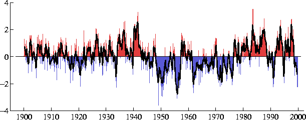
Figure 5: Representation of the Pacific Decadal Oscillation Index based upon monthly sea surface temperature anomalies in the North Pacific Ocean between 1900 to 2000. It is believed that after a long lasting warm phase between about 1977 to 1999 (in red), the on-set of a cold phase is emerging in recent data (in blue). Graphic produced by Dr. Steven Hare from the International Pacific Halibut Commission, University of Washington, Seattle, USA. For more information on the Pacific Decadal Oscillation see also see web link below.
A similar shift in sea surface temperature to that observed initially in the North Pacific Ocean was also found along the South American coast, where temperature data off Valparaiso in Chile reveal a long lasting warming effect since the mid seventies (Figure 6).
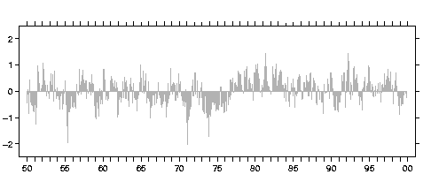
Figure 6: This is a time series of the sea surface temperature anomaly off Valparaiso, Chile, between 1950-1999. The figure was produced by Dr. Todd Mitchell, JISAO, University of Washington based upon data from Smith et al. (1996). Most prominent is the shift from negative to positive anomalies in about 1977.
The formation of water masses in different locations of the world ocean is a mechanism by which climate variability is carried into the interior of the ocean. On the global scale, we have already learned about the importance of the North Atlantic Deep Water. Before this water finally circulates back into the North Atlantic forming part of the global thermohaline circulation, it undergoes several transformation and shallow, basin scale secondary conveyor belt type circulation. These take place in individual ocean basins such as the South Pacific Ocean boarded by South America in the east and Australia in the west (Figure 1). One of these conveyor belt type circulation involves the formation of Sub-Antarctic Mode Water and its transformation into Antarctic Intermediate Water. While North Atlantic Deep Water ventilates the global ocean and replaces deep ocean water with new surface water over several centuries, the formation of mode and intermediate water ventilates the mid depth ocean upon time scales of several decades. The circulation pathway is indicated in Figure 1 as a dashed broad path in the South Pacific Ocean. Newly formed water is removed from the ocean surface by deep surface layer mixing in the Southern Hemisphere winter (Figure 3) and spreads into the interior of the ocean. It recirculates with the basin scale gyres and up-wells in equatorial or polar regions after several decades.
A maximum in the oxygen concentration and a minimum in the salinity characterizes mode and intermediate water. On the global scale, intermediate water is the freshest subsurface ocean water (Figure 7). The low salinity tongue extents from the surface of the Southern Ocean downward and northward in the depth range of about 800-1000 m.
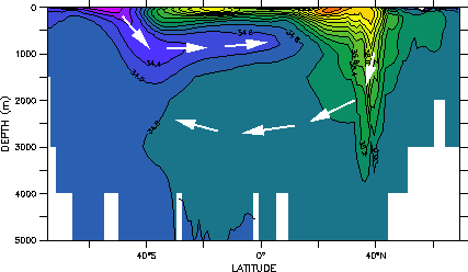
Figure 7: The vertical distribution of salinity is shown for a north to south section across the Atlantic Ocean. In the Southern Ocean low salinity water is produced which sinks to a depth of about 800 - 1000 m and moves as a low salinity tongue into the northern hemisphere (purple to blue shading). The North Atlantic Deep Water is produced in the Northern Hemisphere (in yellow to green shading). It plunges to a depth of about 2500 - 3000 m and moves into the Southern Hemisphere. Both water masses are part of the global conveyor belt circulation (see Figure 7). Arrows indicate direction of ventilation pathway. Data is from the Levitus (1994) climatology.
There seems to be sufficient evidence from both ocean observation and modelling studies, which suggest that one of the regions in the Southern Hemisphere ocean, where this water is removed from the ocean surface, is located in the extreme eastern South Pacific Ocean just off the southern Chilean coast (Figure 8). Low salinity and high oxygen values indicate a rapid ventilation or renewal of subsurface water in this region. Further research into the origin of intermediate water is also carried out by the Program for Regional Studies in Physical Oceanography and Climate at the University of Concepcion (see web link below), Chile, in collaboration with the Danish Centre for Earth System Sciences in Copenhagen (see web link below), Denmark. So far, this work is and was limited to modelling studies of remote ocean processes (Ribbe 2001), and observations away from regions of mode and intermediate water mass formation, but in the future will hopefully also involve field expedition into water mass formation regions just off south Chile.
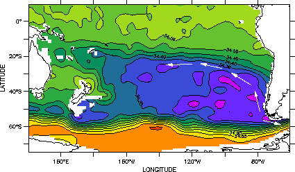
Figure 8: The horizontal distribution of salinity in the South Pacific Ocean at a depth of about 800 m. Australia is located in the west, South America in the east. Lowest salinity is found just to the west of South Chile (shaded in blue to purple). The salinity minimum is characteristic for Subantarctic Mode and Antarctic Intermediate Water which moves into the South Pacific Ocean away from its formation site off Chile. A fraction of intermediate water leaves also the South Pacific Ocean via Drake Passage in the south off Chile and enters the South Atlantic Ocean. Arrows indicate pathways for water masses. Data is from the Levitus (1994) climatology.
Research into the distribution, formation and circulation of mode and intermediate water in the eastern South Pacific Ocean, may be crucial in understanding changes to the global mean state of the world ocean. There may be first indicators that the mean state of the ocean is undergoing changes due to global warming. For example, recent papers published in the peer reviewed literature suggest that the mean climatological state of the Pacific Ocean has changed within the last forty years. Data from modern research cruise were compared with those collected in the 60s. The comparison of subsurface ocean temperatures within the mode and intermediate water found a warming of several tenth of a degree within this level (Figure 9). This finding for the eastern South Pacific is consistent with those obtained for other regions of the Pacific Ocean, which show a Pacific Basin wide warming of the mode and intermediate water level during the last 2-3 decades (Bindoff and Church, 1992). We do not know yet for certain if this warming is a result and first indication of global warming, but it is a finding which indicates that monitoring mode and intermediate water mass properties may help to detect first global climate change signals within the ocean interior.
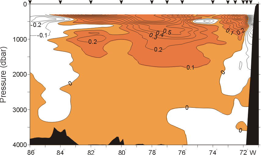
Figure 9: This is the temperature difference computed from data collected in the eastern South Pacific Ocean during 1967 and again in autumn 1995. South America is in the east on the right. No data is shown for the top 300 m which comprises the mixed layer. Largest temperature differences of more than 0.5 oC (shaded in red) are found in a depth range of about 500-800 m within the northward path of Subantarctic Mode and Antarctic Intermediate Water. This warming may indicate a change in the ocean's climatological mean state. Source: Shaffer et al. (2000).
Acknowledgments
The author would like to thank Dr. Todd Mitchell for providing access to data and figures by maintaining a web page at the Joint Institute for the Study of the Atmosphere and Ocean, University of Washington, USA (see link below). Dr. Ole Krarup Leth provided a new Figure 9 first published in Shaffer et al. (2000). I also would like to thank Carlos Moffat at the University of Concepcion for helping to produce the two animation, and Ricardo de Pol-Holz for the translation of the English version of the manuscript. Other graphics were produced using FERRET, an analysis tool developed by E. Harrison and S. Hankin of NOAA's Pacific Marine Environment Laboratory, Seattle, USA.
References
Bindoff, N. L. and J. A. Church (1992), Warming of the water column in the southwest Pacific Ocean. Nature, 357, 59-62.
Broecker, W. S. (1991). The Great Ocean Conveyor Belt. Oceanography, 4, 79-89.
Broecker, W. S., S. L. Peacock, S. Walker, R. Weiss, E. Fahrbach, M. Schroeder, U. Mikolajewicz, C. Heinze, R. Key, T. H. Peng, and S. Rubin (1998). How much deep water is formed in the Southern Ocean. Journal of Geophysical Research, 103, 15833-15843.
Intergovernmental Panel on Climate Change (1995). Climate Change 1995. The Science of Climate Change. Cambridge University Press, Cambridge, 572pp.
Levitus, S. (1994). World Ocean Atlas. Informal Report No. 13, National Oceanographic Data Center, Ocean Climate Laboratory, Washington D.C.
McCartney, M. S., R. G. Curry, and H. F. Bezdek (1996). North Atlantic's transformation pipeline chills and redistributes subtropical water. Oceanus, 39, 19-23.
Munk, W. H. (1966). Abyssal recipes. Deep-Sea Research, 13, 707-730.
Munk, W. H. and C. Stommel (1998). Abyssal recipes II. Deep-Sea Research, 45, 1977-2000.
Ribbe, J. (2001). Intermediate Water Mass Production Controlled by Southern Hemisphere Winds. Geophysical Research Letters, 28, 535-538.
Siedler, G., J. Church, and J. Gould (2001). Ocean Circulation and Climate. Observing and Modelling the Global Ocean. International Geophysics Series, Vol. 77, Academic Press, San Diego, 715pp.
Shaffer, G., S. Hormazabal, O. Pizarro, and S. Salinas (1999). Seasonal and interannual variability of currents and temperature off central Chile. Journal of Geophysical Research, 104, 29951-29961.
Shaffer, G., O. Leth, O. Ulloa, J. Bendtsen, G. Daneri, V. Dellarossa, S. Hormazabal and P.-I. Sehlstedt (2000). Warming and circulation change in the eastern South Pacific Ocean. Geophysical Research Letters, 27, 1247-1250.
Smith, T. M., R. W. Reynolds, R. E. Livezey, and D. C. Stokes (1996). Reconstruction of historical sea surface temperatures using empirical orthogonal functions. Journal of Climate, 9, 1403-1420.
Stommel, H., and Arons, A. B. (1960a). On the abyssal circulation of the world ocean - I. Stationary planetary flow patterns on a sphere. Deep-Sea Research, 6, 140-154.
Stommel, H., and Arons, A. B. (1960b). On the abyssal circulation of the world ocean - II. An idealized model of the circulation pattern and amplitude in oceanic basins. Deep-Sea Research, 6, 217-233.
World Wide Web Links
Intergovernmental Panel on Climate Change: http://www.ipcc.ch/
Climate and Variability Program: http://www.soc.soton.ac.uk/CLIVAR
TAO-TOGA array: http://www.pmel.noaa.gov/toga-tao/home.html
El Nino Theme page: http://www.pmel.noaa.gov
Program for Studies in Regional Oceanography and Climate: http://www.profc.udec.cl
Danish Centre for Earth System Science: http://www.dcess.ku.dk
Pacific Decadal Oscillation: http://topex-www.jpl.nasa.gov/discover/PDO.html
World Ocean Circulation Experiment: http://www.soc.soton.ac.uk/OTHERS/woceipo/ ipo.html
The Author
The author is a physical oceanographer who works now as a Lecturer in Climatology at the University of Southern Queensland in Australia. He was a researcher and associate professor at the University of Concepcion in Chile within the Program for Regional Studies in Physical Oceanography and Climate and has a long standing interest in large scale ocean modelling, climate processes, and the role of the ocean within the climate system. For further information, suggestions and other comments, please contact the author on Joachim.Ribbe@usq.edu.au.
Glossary
Antarctic Circumpolar Current: An ocean current with a lengths of about 16.000 km and which flows eastward around Antarctic
Antarctic Circumpolar Wave: An ocean phenomenon, first observed as a temperature anomaly travelling eastward around Antarctica in about 7-8 years.
Antarctic Intermediate Water: A volume of water (water mass, see below) that originates in the Southern Ocean and can be found in ocean depth of about 800-1000 m. It is partly composed of rejuvenated North Atlantic Deep Water.
Climate Change: Climate can be defined as the average weather. It is described through climate elements such as temperature and rainfall. If averaged over certain periods (e.g. 100 years) and regions (e.g. the whole planet), the climate elements describe a particular climate
Climate Variability: These are fluctuations or oscillations in those elements which describe a climate for a given period and location. The El Nino Southern Oscillation (see below) leads to climate variability or oscillations with a period of about 3-4 years. Another example is the Pacific Decadal Oscillation with a period of about 20-30 years.
El Nino Southern Oscillation: A coupled ocean and atmosphere phenomenon that is associated with changes in the strengths of the trade winds. It leads to unusual ocean warming and cooling in the equatorial Pacific Ocean.
El Nino: The warm phase of the El Nino Southern Oscillation that results in an unusual warming of the eastern Pacific Ocean.
Enhanced Greenhouse Effect: An enhancement of the natural greenhouse effect (see below) due to the human induced release of trace gases or greenhouse gases such as carbon dioxide into the atmosphere.
Freshwater Flux: The gain/loss of water to/from the atmosphere
Global Thermohaline Circulation: A global ocean circulation that seems to be driven by the formation of North Atlantic Deep Water and spans the whole planet. The circulation is often also referred to as a conveyor belt circulation.
Heat Flux: The gain/loss of energy to/from the atmosphere.
La Nina: The cold phase of the El Nino Southern Oscillation resulting in an unusual cooling of the eastern Pacific Ocean.
Natural Greenhouse Effect: The natural presence of trace gases or greenhouse gases such as carbon dioxide in the atmosphere results in a warming of Earth and leads to a global mean temperature of about 15 oC.
North Atlantic Deep Water: A water mass (see below) formed in the North Atlantic Ocean. It spreads in depths of about 1500-2500 m southward into the Southern Hemisphere and forms part of the global thermohaline circulation (see above).
Ocean Ventilation: Refers to the physical process which leads to the replacement of deep ocean water with surface water.
Pacific Decadal Oscillation: An anomaly to the sea surface temperature resulting in a warm (above average temperature) and cold (below average temperature) phase each lasting about 20-30 years. Observed initially in the North Pacific Ocean, but also discovered recently in the South Pacific Ocean.
Subantarctic Mode Water: A volume of water formed in the Southern Ocean which occupies the depths range of about 200-600 m.